Composition + structure
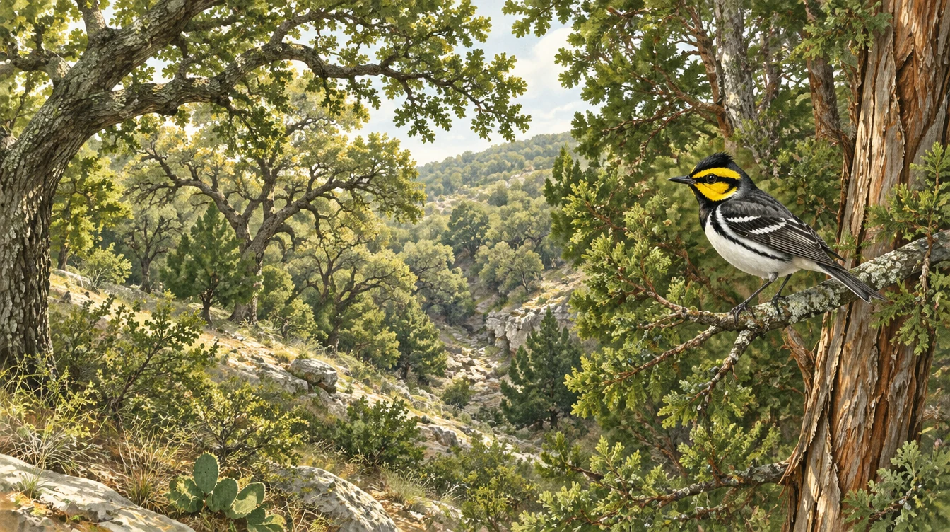
Document the tree mix, maturity, canopy height and cover together.
Texas Hill Country · An interactive field reference
Learn to read the woodland—from the trees and terrain to the canopy that supports a breeding bird.
Free reference · Plant gallery · Territory explorer · Fillable formA reference for looking closer. Use the illustrations to recognize features and organize evidence. Habitat suitability requires a site assessment; this tool does not establish occupancy or authorize clearing.
01 / The whole woodland
Mature juniper, a hardwood mix and connected canopy tell a more useful story together. Select the markers to explore the landscape.
Document the tree mix, maturity, canopy height and cover together.
Include adjoining woodland and uplands in the assessment context.
Photographs, field notes and mapped vegetation units make the reasoning reviewable.
02 / The plant gallery
Explore 18 representative trees and woody associates. These are examples across habitat descriptions and regional woodland—not a complete flora or a checklist of plants every site must contain.
Showing 6 plants
Illustrations support recognition; use a botanical key and field characters to confirm identification. Common names such as live oak, shin oak, walnut and hackberry can refer to more than one taxon. TPWD woodland associations ↗ · TPWD Hill Country ecology ↗ · Cornell habitat account ↗
03 / A bird’s space
Golden-cheeked Warblers breed in central Texas and winter in southern Mexico and Central America. A male’s breeding territory is commonly described as about 4–10 acres; actual territories vary. USFWS range overview ↗ · Territory estimate ↗
6.0 acres ≈ 2.43 hectares.
04 / Life in the canopy
A nest and a feeding bird make the connection tangible. These scenes are illustrations, so visitors can learn without approaching an active nest.
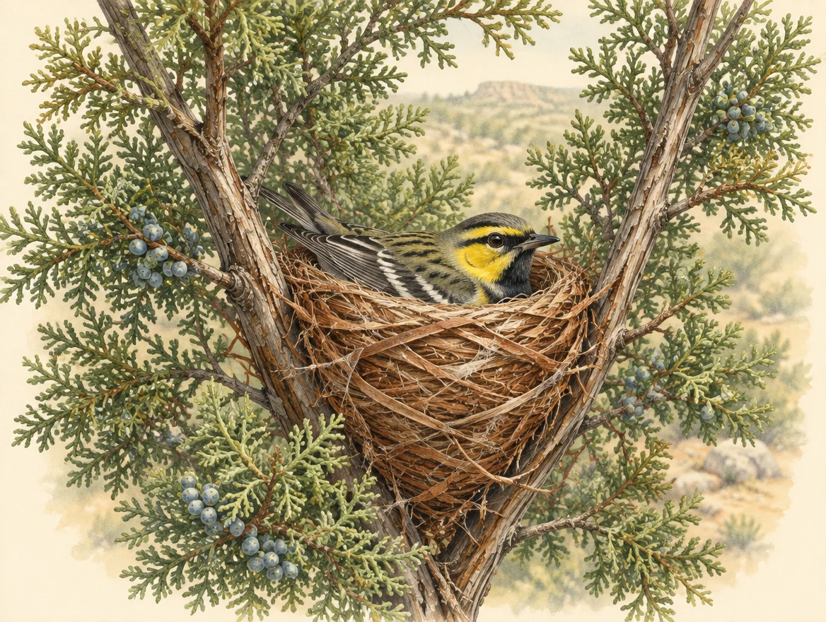
The nest
The female weaves strips of juniper bark with other plant material and spider silk. Nests are often high in juniper or oak; Cornell describes typical heights of 16–23 feet and an average outside width around 3.2 inches.
Observe from a distance. A habitat assessment does not require locating or approaching a nest.
Nest placement and construction ↗The tree’s name is Ashe juniper. Its mature, shredding bark is a key part of this bird’s nesting story.
Caterpillars are important prey, alongside spiders and insects such as aphids, beetles, flies and ants. These are prey-group examples, not species identifications or a complete diet. Food and foraging ↗
10-second Higgsfield animated illustration. A Golden-cheeked Warbler takes a green caterpillar from a leaf and leaves the branch. Play when ready; this is not documentary footage.
05 / The official reference
Primary reference: USFWS Austin ESFO, Requirements for Conducting Presence/Absence Surveys and Habitat Assessments for the Golden-cheeked Warbler, July 2025. Check for updates before use.
The protocol describes potential habitat associations and separate survey methods. A habitat assessment alone does not establish that birds are absent.
“a lack of a response does not imply our concurrence.”
USFWS, habitat-assessment reporting section, page 4.
Read the full official requirements ↗The agency descriptions consider mature Ashe juniper with hardwoods, canopy cover and height, and landscape position. Examples include mesic slopes and canyons, adjoining uplands, and some creek-bottom or oak-dominated associations.
They describe mature juniper around 15 feet tall and 5 inches in diameter, typical closed woodland with 50–100% canopy and a 20-foot canopy height, plus additional associations near 35% cover. Read each association in full; these are not a universal pass/fail formula.
Read TPWD’s complete habitat descriptions ↗Within the scientific-permit framework, the July 2025 protocol calls for reporting when an area meeting its potential-habitat descriptions is not surveyed. It recommends submission promptly, preferably within five business days and ahead of clearing; individual permit conditions may be stricter.
Submit to GCWAreporting@fws.gov with subject GCWA Habitat Assessment. USFWS does not provide affirmative concurrence. Follow applicable permit conditions and any agency response.
This checklist helps prepare a package; it does not decide whether a permit or submission is required for every landowner.
Reporting scope and conditions ↗06 / From observations to a record
Use Elizabeth’s fillable habitat form with this step-by-step preparation checklist. The form is a TTB template; the linked agency instructions control the submission format.
USFWS prefers a GIS polygon shapefile; Excel requires a matching, accurately located boundary map. Combine the reporting year’s area data into one file per permit. Use separate entries for the assessment boundary and unsurveyed suitable habitat, with matching property names.
| Field | Record |
|---|---|
| Prop_Name | Property or assessed portion; match map labels |
| Prop_Acres | Area in acres |
| Site_Type | Property/Assessment Area Boundary TPWD Habitat not surveyed |
| Comp_Name | Responsible company, organization or individual |
| Date | Completion date as YYYYMMDD |
Consult the current template for field types, lengths and naming. For multiple GIS polygons of the same Site_Type in one assessment, the instructions call for a multipart geometry. Suitable habitat already surveyed belongs in the separate survey-area dataset.
Official area-data instructions ↗Entries stay in this open page and disappear on reload. Download before leaving. Nothing is sent to TTB or USFWS; submit the completed package separately through the appropriate agency channel.
I can help scope the habitat assessment, document the evidence and explain the next steps.
Reference reviewed September 28, 2026. Agency documents: July 2025 editions. Biology: Cornell Lab of Ornithology and TPWD. Follow the current official documents and project-specific conditions.
Habitat scenes, plants, prey and animation were created with Higgsfield as educational illustrations. They are not field photographs, measured vegetation, occurrence records or a botanical identification key. The territory diagram depicts no real nest or property.
Federal GCWA recovery permit ESPER32178096-0. Permit-covered TTB fieldwork begins after required Texas authorization and written access permission are confirmed.